
.png?width=500&name=InsitePro4%20(1).png "InsitePro Logo")

The fifth and final installment of my series comparing InsitePro™ to RiskMeter Online™ addresses a major convenience: InsitePro is not limited to an address. (Please read posts one, two, three, and four to learn about the other advantages of InsitePro over RiskMeter Online.)
InsitePro, like RiskMeter Online, handles addresses as input to determine the risk from multiple perils at a specific location. But what if your location is a power plant, a factory, or a pipeline? A single point is not enough, and an address doesn’t adequately describe the full location.
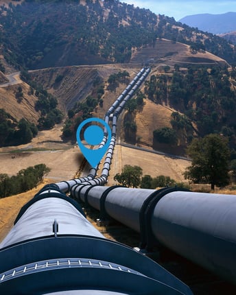
InsitePro is built on Google Maps, which allows users to first hone in on a location (like RiskMeter), but then to navigate around the initial pin point location to get a wider view of the risk. For properties with large footprints, this is essential for understanding the risk. Different parts of the property might have different exposures to natural catastrophe, and the overall risk depends on the whole picture. If the “location” is actually a pipeline (maybe hundreds of miles long), a single pin point is definitely inadequate.
In a way, this comparison is similar to the global reach comparison, in that InsitePro doesn’t limit your view of risk to a single country. Not only does our software go beyond borders, it goes beyond properties, too. For many users, InsitePro addresses a need that RiskMeter can’t always serve.
For more information on the top 5 advantages of InsitePro over RiskMeter Online, please download my free eGuide by clicking below.


Comment Form