
.png?width=500&name=InsitePro4%20(1).png "InsitePro Logo")

In my previous post, I explored the two earthquake metrics that help insurers understand the likelihood of an earthquake affecting a specific location. This post is about the two metrics that express the severity of property damage in the event an earthquake does occur.
 Unlike the science behind earthquake forecasting, which has limited capabilities, the science behind the civil engineering that enables buildings and structures to withstand earthquakes is well developed. Insurance analytics and earthquake models leverage this engineering know-how to estimate potential damage (or vulnerability, to use the modeling term) for a given building.
Since the vulnerability is better understood than the likelihood, almost all insurance analytics include vulnerability. Some insurers and brokers evaluate earthquake risk entirely on vulnerability. Jumping straight to vulnerability means the risk assessment of a building is actually a rating or pricing analysis — unlike flood modeling, where many available risk analytics present a lot of information before pricing and rating takes place.
There are two key metrics used to understand the vulnerability of a building: soil type and peak ground acceleration.
Soil type is a critical factor, because the density of the ground has a direct effect on the amount of motion the ground will experience during a quake. Hard ground propels the energy quickly with a small amplitude, while soft ground slows the energy down and increases the amplitude of the motion. The U.S. Geological Survey (USGS) has a standard scale describing soil types, with Type A being susceptible to the smaller damaging motion, and Type F residing at the other end of the spectrum.
- Type A: Hard rock (igneous rock)
- Type B: Rock (volcanic rock)
- Type C: Very dense soil and soft rock (sandstone)
- Type D: Stiff soil (mud)
- Type E: Soft soil (artificial fill)
- Type F: Soils requiring site-specific evaluation
Another important aspect of soil type is the possibility of liquefaction, which is when the moisture content of the ground, when agitated, disturbs the support structure of the dirt and turns it into a liquid mess. The transformation of solid ground to mud beneath a building has obvious consequences. Types D, E, and F are subject to liquefaction, and thus higher vulnerability for structures built on it.
Peak ground acceleration (pga) is the second metric describing vulnerability. This measurement is taken directly from the engineering used to build earthquake-resilient structures, which is a useful correlation between building types (or even better, building codes) and potential damage. Unlike all the other earthquake metrics discussed, this one is measured with instruments deployed around the world to record the movement of the Earth, meaning the sensitivity and understanding of the metric is well refined. The pga is expressed as a decimal of g, or the gravitational acceleration at sea level. It is interesting to compare non-intuitive pga values with observed earthquake intensity:
- 0.001 g – perceptible by people
- 0.02 g – people lose their balance
- 0.50 g – very high; well-designed buildings can survive if the duration is short
It’s also neat to compare pga values on a more granular level to experienced sensation and vulnerability:
| Acceleration | Perceived Shaking | Potential Damage |
| < 0.0017 | Not felt | None |
| 0.0017 – 0.014 | Weak | None |
| 0.014 – 0.039 | Light | None |
| 0.039 – 0.092 | Moderate | Very light |
| 0.092 – 0.18 | Strong | Light |
| 0.18 – 0.34 | Very Strong | Moderate |
| 0.34 – 0.65 | Severe | Moderate to heavy |
| 0.65 – 1.24 | Violent | Heavy |
| > 1.24 | Extreme | Very heavy |
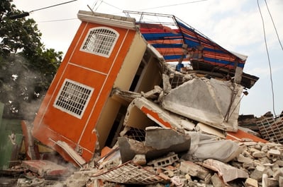
However, these metrics don’t always track accurately with the damage caused by an earthquake, because there is another aspect to them that can’t be modeled or predicted: duration of the quake. The Great Alaskan Earthquake of 1964 had a relatively low pga of 0.18 (i.e., moderate damage potential, as per the chart above), but it basically destroyed large parts of Anchorage and other towns because it lasted for over four and a half minutes!
Even though earthquake models have a long historical record and rich datasets to leverage, they can only aspire to be useful estimations of when and how bad an earthquake might happen. For insurers, earthquake models and analytics are indispensible, even though they are flawed. Unlike with flood, reducing the underwriting leakage on earthquake is very difficult because the inherent uncertainty is unavoidable.
Competition around earthquake insurance depends less on analytics than on the appetite, capacity, and experience of a carrier. Broking earthquake coverage is focused on sharing the best possible information with property owners and carriers to simply get the best possible coverage and price combination. When the next big urban earthquake strikes, it will catch everyone by surprise, but nobody will be surprised.


Comment Form